Recognizing the opportunities drones provide for agriculture, CTA launched the project Transforming African Agriculture: Eyes in the Sky, Smart Techs on the Ground in 2016 to provide technical assistance to start-ups across Africa.
Unmanned aerial systems (UAS) are playing an increasingly prevalent role in precision agriculture. The technology provides farmers with near real-time data on their land, crop, and livestock in order to assist them in maximizing input efficiency, reducing environmental impacts and optimizing product quality. To open up these opportunities to farmers in Madagascar, “Transforming Africa’s agriculture: Eyes in the sky, smart techs on the ground”, a CTA-funded project, has recently provided representatives from Farming & Technology for Africa (FTA) and a network of NGOs, known as BIMTT, with training to conduct drone operations. BIMTT is specifically interested in adopting the technology in the context of land tenure rights, while FTA intends to use drones for forestry and reforestation development.
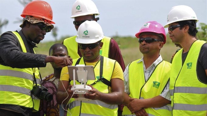
In order to respond to specific training requests and to increase the project’s outreach, CTA contracted Global Partners – a company that develops digital solutions for agriculture, urban planning, and biodiversity conservation – to deliver training to a team from Madagascar in October 2019. Composed of researchers, GIS analysts, certified drone operators, and agronomists, Global Partners has developed one of just a few drone training programs in Africa and has been training researchers, students and young entrepreneurs since 2013 on the safe use of drones for development.
Training for the Madagascan team was delivered through a participatory workshop in Benin. Designed as a series of hands-on activities, the training introduced participants to the use of UAS in forestry and land use management. Topics discussed included the understanding of drone safety, privacy principles and regulations, management and processing of remote sensing data, and setting-up drone operations in Madagascar.
At the end of the training, participants had gained practical skills and knowledge on how to:
- Fly different unmanned aerial vehicles (UAVs – with fixed wings and multi-rotors) safely and responsibly;
- Choose the best sensor and analytical software for a given purpose;
- Collect, manage, and analyze data collected with UAVs; and
- Design and implement UAV programs in Madagascar.

In order to assess the knowledge and skills gained by the participants during the training, they were put to work on a practical project to develop a UAS-based solution responding to a concrete development challenge using low-cost UAS and GIS software. The objective of this challenge was so trainees could demonstrate how to plan a mission, pilot the drones responsibly to collect data, and analyze the data to generate information for action.
Andrianjafy Rasoanindrainy, FTA director, summarizes the project as follows: Our task consisted of preparing all the documentation needed to conduct a mission aimed at estimating the yield of a tomato crop over an area of 800m2. Activities included formulating the request to obtain authorization to conduct a flight via the competent authorities, drafting the flight plan and protocols for data capture using the multispectral sensor, and analyzing the imagery using Pix4Dmapper software.
“My colleagues back home told me that I suddenly sound very enthusiastic on the phone, explains Rasoanindrainy. This is probably because I now clearly see how we can make practical use of this transformative technology. UAVs seem to have many applications that people in Madagascar aren’t aware of. I believe that the introduction of such technology in our country will bring significant progress.”
Rajoelisolo Kotondrajaona, BMITT secretary-general reported: “We have trained 2,500 people in land rights during the last semester. We are going to use drones to collect more detailed data on the different lands with land rights issues: area, numbers of plants, number of houses, etc. Now we want to buy drones. Board members are already convinced by the use of such material. We have contacted technicians from the land rights administration to convince them about the reliability of the collected data with drones but it is not always easy to introduce new technologies.”

Having been exposed to the technology, the delegates from Madagascar are now gearing up to introduce UAVs and UAS in their country with the support of Africa Goes Digital Inc. (AfGD), an industry association of African digital service providers. Although only recently established, AfGD is currently made up of 38 African enterprises, two universities, and three government agencies across 21 African countries. The member companies provide digital services in the sectors of agriculture, energy, surveying, geographical information systems, engineering, construction, oil and gas, disaster risk management, humanitarian research, and capacity building in the use of drone technology. AfGD members have started contributing to the transformation of African agriculture where decisions are increasingly based on real-time information, and it is expected that the training of Malagasy actors in drone technology will also contribute towards transformation on the continent – and to meeting national plans to stimulate digital agriculture.
